
This article was first published on LinkedIn on April 15, 2026. Link to original article.
Chinese Satellite Imaging
The Satellite Blackout That Isn’t
In early April 2026, the US government requested that commercial satellite imagery providers withhold images of Iran and the wider Middle East conflict zone. The companies involved depend on US government contracts, and they have complied with the order.
The implication is that commercial imagery has put American forces at risk.
Does withholding US commercial imagery actually deprive America's adversaries of meaningful capability?
Short answer: No.
China has not imposed a blackout, and it offers exceptional satellite imaging capability.
Was US Commercial Imagery Actually Being Used Against US Forces?
A Chinese intelligence aggregator, MizarVision, posted satellite imagery of American aircraft at a Saudi Arabian air base shortly before Iran attacked it. MizarVision does not operate its own satellites — it sources imagery commercially. A recent Flight Global article cited the South China Sea Strategic Situation Probing Initiative (SCSPI), which suggests that MizarVision uses imagery from Western commercial providers.
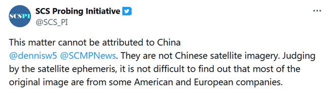
MizarVision may have used Western imagery, but it certainly didn’t need to. Plenty of home-grown data was available.
China's Satellite Fleet
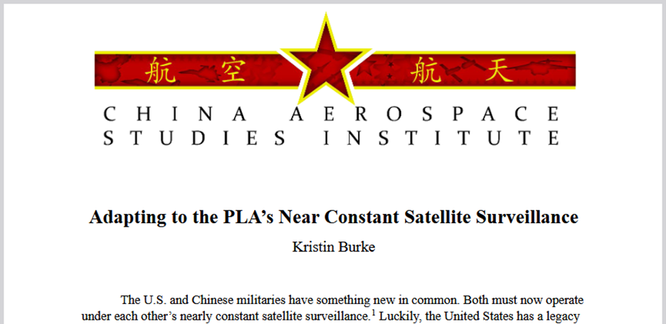
China's satellite imaging capability is poorly understood in Western public discourse, though certainly well understood by Western intelligence analysts. In March 2025, the US Air Force's China Aerospace Studies Institute published a report titled Adapting to the PLA's Near Constant Satellite Surveillance.
The Chinese government operates at least 45 optical imaging satellites, and 28 synthetic aperture radar (SAR) satellites on classified programmes.
Some of these satellites are believed to have exceptional capabilities. Three satellites watch continuously from geostationary orbit – two optical (Gaofen-13 with ~15m resolution, and Yaogan-41 with ~2.5m according to some sources), and one radar (Ludi Tance-4, ~20m). Closer to Earth, four Gaofen-11 satellites reportedly can image at 10cm resolution.
But these classified satellites only tell part of the story.
China's 'Commercial' Satellite Fleet
China’s commercial satellite imaging industry is vast and growing rapidly. Chinese 'commercial' operators are not independent enterprises in the Western sense: they are generally at least partly state-owned, and they operate within a framework of Chinese government direction. The commercial/military distinction is blurred.
The leading operator is Chang Guang Satellite Technology Ltd. (CGSTL). Its Jilin constellation has no equivalent outside China. Over 140 satellites have been launched, of which 87 imaging satellites are believed to be currently operational. Eleven of the 87 are recent ‘Kuanfu’ variants, which use multiple cameras to capture imagery at a claimed 50cm resolution across swaths of up to 150km in a single pass. Even allowing for the challenges of stitching multi-camera imagery and correcting for distortion, this is more than adequate for identifying ships, aircraft and large military vehicles across a vast area.
China's commercial fleet also includes 37 hyperspectral and thermal imaging satellites, which can identify objects that are invisible or ambiguous in conventional optical imagery, and 37 synthetic aperture radar satellites capable of imaging through clouds and in darkness.
Comparison: China vs USA Commercial Satellites
The best US satellites currently provide better quality images than their Chinese counterparts. But when it comes to quantity, particularly of high-resolution satellites, China has taken a lead which will continue to grow as more satellites are launched:
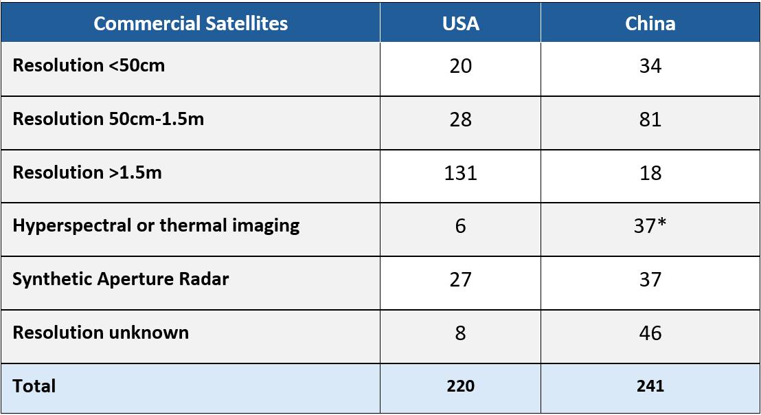
See the tables in the Appendix for a more detailed breakdown.
Freely Available - But Not to Americans
Chinese commercial satellite imagery is not accessible to US customers. CGSTL was sanctioned for allegedly supplying imagery used by Russia in Ukraine. A separate company, SpaceTy, was sanctioned for providing imagery used by Houthi forces in Yemen. Given the breadth of US sanctions and the opacity of Chinese satellite data supply chains, US entities cannot safely purchase imagery from any Chinese commercial provider without material sanctions risk.
CGSTL is also subject to EU sanctions, though imagery from other Chinese operators can be purchased in Europe.
In most countries, however, Chinese operators are not sanctioned, and Chinese commercial satellite imagery is available for purchase. Whatever access controls Chinese operators may impose, there can be no guarantee that images regarded as sensitive by the United States will not reach US adversaries.
What Should the West Take From This?
The restriction on US commercial satellite imagery may make it harder to publish potentially damaging open source intelligence. However, it also prevents Western media from assessing the impact of the war. Some politicians may see this as a desirable outcome.
But the restriction does not give meaningful protection to US interests. China has built the world's largest commercial imaging constellation - one with revisit frequency, coverage, and all-weather radar capability that US commercial providers cannot match. That constellation can actively image the conflict zone, and the US cannot make it stop.
There is a fundamental asymmetry. China has constructed a commercial space sector that is globally available, state-directed when required, and immune to American regulatory reach.
The sky above the Persian Gulf is not blacked out. It is watched, continuously, from the east.
Note on sources
This analysis is based on a detailed dataset of Chinese imaging satellites that I have compiled from multiple sources. I’m happy to share the underlying data with anyone working on related questions. Please contact me using the contact form at the bottom of this page.
Appendix
Chinese Commercial Satellite Fleet - Detail
China currently operates 241 non-classified commercial imaging satellites, broken down by constellation operator as shown below.
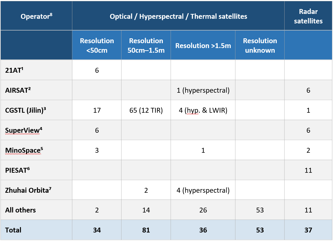
Notes:
1. Twenty First Century Aerospace Technology (21AT). https://www.21at.sg/
2. AIRSAT Technology Group, founded by the Aerospace Information Research Institute of the Chinese Academy of Sciences. http://en.airsat.com.cn/
3. Chang Guang Satellite Technology Co. (CGSTL). https://www.jl1.cn/EWeb/index.aspx
4. SuperView, operated by SpaceWill (formerly Beijing Space View Technology Co.). https://en.spacewillinfo.com/
5. MinoSpace. https://en.minospace.cn/
6. PIESAT Information Technology Co. https://www.piesat.cn/en-us/
7. Zhuhai Orbita (trading as Orbita Aerospace). https://www.obtdata.com/en/index.html
8. Attributing satellites to a single operator can be difficult, as the same assets sometimes appear in communications from multiple companies.
US Commercial Satellite Fleet - Detail
The United States currently operates 226 non-classified commercial imaging satellites. Of these, 205 belong to the operators shown in the table below.
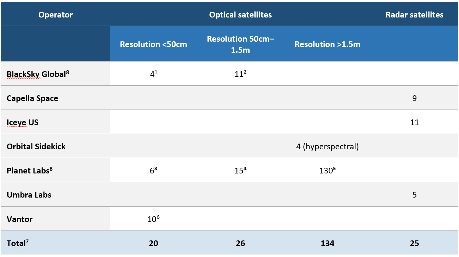
Notes:
1. BlackSky Gen-3 satellites; claimed resolution 35cm. Launched 2025–2026.
2. BlackSky Gen-2 satellites; claimed resolution 90cm. Launched 2018–2023.
3. Planet Pelican satellites; claimed resolution 30cm. Launched 2023–2025.
4. Planet SkySat satellites; claimed resolution 50cm. Launched 2014–2018.
5. Planet Dove satellites; claimed resolution 3.7m. Launched 2023–2025.
6. Vantor WorldView and Legion satellites; claimed resolution 31–50cm. Six Legion satellites launched 2024–2025; WorldView satellites launched 2007–2014.
7. An additional 15 commercial satellites carrying imaging payloads are not shown here.
8. The claimed resolutions for BlackSky and Planet frequently appear to exceed the theoretical limits of their optical systems, suggesting significant computational enhancement. Actual imaging resolution is likely worse than stated.
About the Author: Adrian Norris
Adrian Norris is an aerospace advisor with over 30 years of international experience spanning strategic consulting, aviation and space startups, and corporate leadership. He works with investors, founders, and executives to shape strategy, assess feasibility and risk, and distinguish real opportunities from industry hype. He was the co-founder of a satellite imaging company which launched an experimental high-resolution imaging satellite in partnership with the Royal Air Force in 2018.
Contact
Get in touch to discuss a current project or investment.
We provide independent, evidence-based analysis to support investment and strategic decisions.