
This article was first published on LinkedIn on October 30, 2025. Link to original article .
Very Low Earth Orbit
VLEO means orbits between 250km and 400km altitude - much lower than most satellites in conventional 'Low Earth Orbit', or LEO.
Some market analysts predict that VLEO is going to be the Next Big Thing. Here are some (rather inconsistent) quotes from Research And Markets, GII Research, Juniper Research and Novaspace:
Very Low Earth Orbit (VLEO) Satellite Global Market Forecasts 2025-2034 | Market to Grow at a Staggering CAGR of 73.9%
The global Very Low Earth Orbit (VLEO) Satellite market is projected to grow from US$ 7.59 million in 2024 to US$ 1.48 billion by 2030, at a Compound Annual Growth Rate (CAGR) of 140.84%
Investment into VLEO satellites will reach $220 billion by 2027; growing substantially from $17 billion this year.
2025 marks the start of the disruptive VLEO era for EO growth.
Are they right?
Probably not. Let’s examine why.
VLEO has some benefits
I'm sceptical about VLEO, but it does have some benefits:
Higher resolution imagery
The closer you are to an object, the more clearly you can see it. The resolution (Ground Sampling Distance or GSD) of satellite imagery is directly proportional to orbital altitude. A satellite offering 50cm GSD from 600km could achieve 25cm from 300km.
In practice, optical quality and the aperture of the telescope impact resolution, which is invariably worse than the theoretical GSD. But, undeniably, closer is better.
Lower debris risk
Orbital debris persists for decades above 500km, and for centuries above 750km. The quantity of debris is increasing, presenting a growing risk to satellites in LEO.
Below 400km, atmospheric drag quickly removes debris, making VLEO ‘self-cleaning’.
If collisions or, in the worst case, use of anti-satellite weapons made existing orbits unusable, VLEO could remain a safe operating zone.
But some claimed benefits... aren’t!
VLEO advocates claim two additional benefits that don’t stand up to scrutiny.
Reduced latency
Lower altitude shortens signal path between Earth and a satellite by roughly 1ms each way. This is a negligible benefit for most applications.
However, coverage from VLEO shrinks drastically. Each satellite is visible for only seconds and serves a small footprint on the ground. Maintaining continuous connectivity would require thousands of satellites plus inter-satellite relays, erasing any latency benefit.
Lower launch cost
The lower the orbital altitude, the less energy is needed for launch. But operational satellites in VLEO must carry more propellant to maintain altitude, and they are likely to be heavier to counter atmospheric drag effects. The increase in launch mass offsets the energy saving from the lower altitude launch.
VLEO Challenges
The drawbacks of VLEO outweigh the benefits, at least for commercial operations. Some drawbacks are frequently mentioned - others, much less so.
Atmospheric drag
The biggest challenge of VLEO is atmospheric drag. The atmosphere extends many hundreds of kilometres above the Earth’s surface (swelling in periods of high solar activity), and its density increases exponentially with lower altitude. So satellites are far more affected by drag in VLEO than in LEO.
Satellite design can mitigate drag effects – e.g. reduced cross section area, streamlined shape without external solar panels, higher mass – but extended operations in VLEO require use of propulsion to fight the continual orbital decay.
Ultimately, satellites in VLEO have shorter operational lives than higher-orbiting satellites. They use more fuel, generate less power from smaller solar panels, and they are heavier and less agile.
Reduced field of view and revisit frequency
The market analyses do not mention that VLEO satellites have a reduced field of view, but it is a limitation with significant consequences.
The map below shows the area that could be imaged by satellites directly overhead Paris from 250km, 500km and 650km – assuming imaging capability of ±30° off-nadir (nadir = vertically downwards):
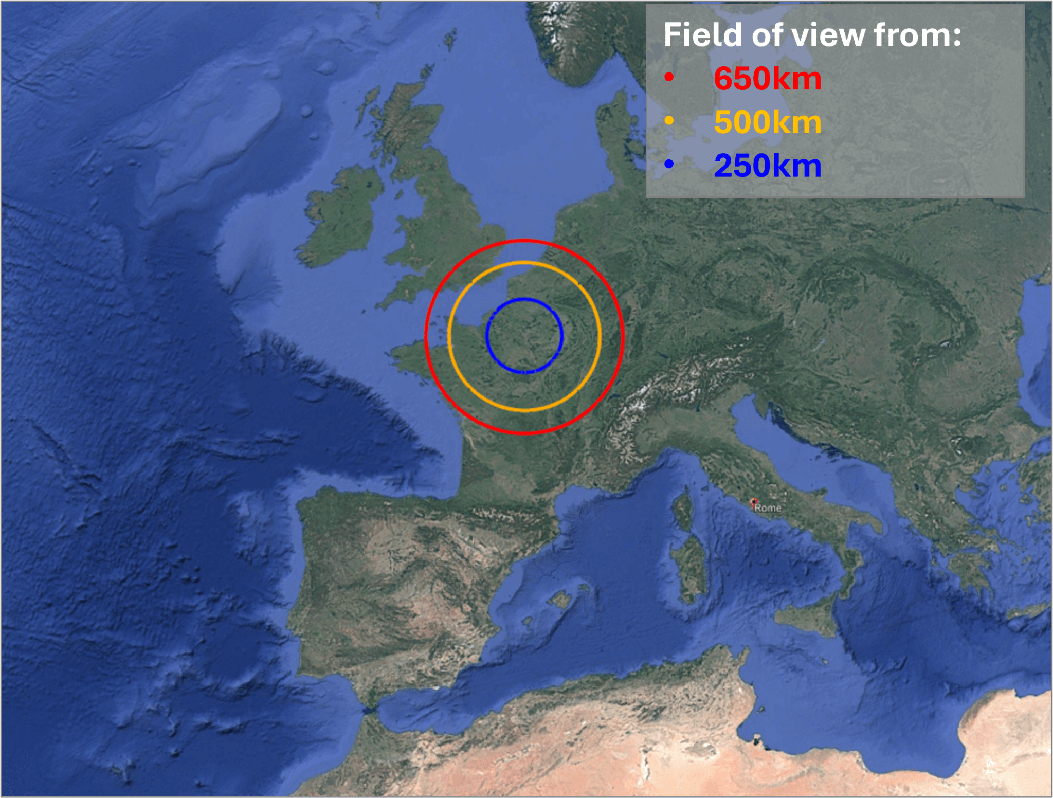
Consequently, the time between imaging opportunities for any target lengthens significantly.
What does that mean in practice? The table below shows the number of days between imaging opportunities for satellites at different altitudes. As before, it assumes imaging capability of ±30° off-nadir.
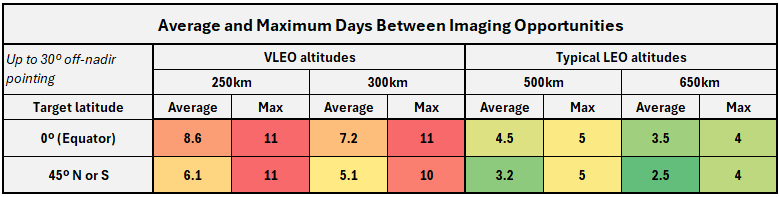
The averages are slightly misleading. I simulated the first 25,000 orbits of a satellite at 250km – representing 4.25 years of operations (far longer than most VLEO satellites are likely to operate). Assuming a target at the equator:
- 182 orbits provide imaging opportunities.
- 135 times, there are 11 days between imaging opportunities
- 2 times, there are 10 days between imaging opportunities
- 44 times, there is an imaging opportunity the day after the previous opportunity.
Many more satellites needed to do the same job
To achieve daily coverage of any given target (again, assuming up to ±30° off-nadir imaging) requires:
- 4 satellites at 650km
- 5 satellites at 500km
- 11 satellites at 250km
Satellites in VLEO have a much shorter operational life, due to atmospheric drag. Optimistically assuming that a satellite at 250km can operate for 1/3rd of the life of a satellite at 650km, 33 satellites would need to be built and launched to sustain the same coverage – far costlier overall than four high-performance satellites in a higher orbit.
Reduced imaging capacity per satellite
At 250km, a satellite remains within imaging range of a target for up to 40 seconds (assuming ±30° off-nadir imaging, and a pass directly overhead the target). At 500km, this increases to 84 seconds, and at 650km it is 113 seconds.
Relatively low-cost satellites use CMOS imagers similar to those found in digital cameras. Precise “panning” is needed to avoid motion blur – rotating the satellite as it captures an image, so that light reflected from the target is focused onto the same pixels throughout the exposure time.
It takes time to set up this precise movement and allow it to stabilise, and it needs to be done for each image. Consequently there will be a long gap between targets while the satellite adjusts its orientation and sets up the correct rate of movement to compensate for its motion. If you want to photograph two targets that are close together – well, you can’t.
More expensive satellites use a different type of camera that does not require this “panning” motion, and they use powerful gyroscopes to allow rapid attitude changes so that multiple nearby targets can be photographed as the satellite passes overhead. But this capability is very expensive for a short-lived VLEO satellite.
Reduced time for data downlink
An imaging satellite needs to download its data to the ground, and receive tasking instructions. For observation satellites in sun-synchronous orbits, the most popular ground station is on the Svalbard archipelago, at 78º North – just 700 miles from the North Pole.
The image below shows the areas within which a satellite can communicate with the Svalbard ground station, assuming that it needs to be at least 20º above the horizon for successful communication.
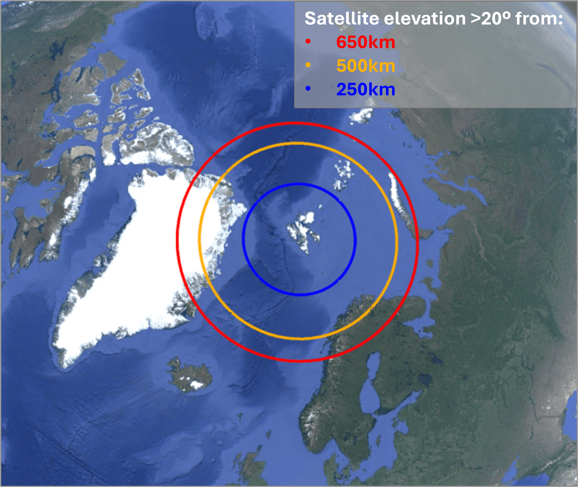
A satellite at 250km would have at most 152 seconds per pass to download data. On some orbits, it won’t come within range of the ground station.
A satellite at 650km will come within range of the ground station on every orbit, and its communication time will be up to 340 seconds.
Other downlink options exist: optical downlink, or relay satellites. But they increase cost and complexity.
Reduced power
Drag precludes use of large solar panels in VLEO. Satellites must use body mounted panels, which will have a smaller surface area.
This means less power is available for manoeuvring the satellite, or downloading data. This will further restrict the operational capability of the satellite compared to one in a higher orbit.
What about VLEO for communications satellites?
All these drawbacks also apply to communications payloads, magnified by the need for continuous coverage. A viable VLEO network would require an enormous constellation with complex inter-satellite links and constant replenishment as short-lived satellites re-enter the atmosphere.
The marginal latency improvement cannot justify the capital cost of such a constellation.
Commercial activity in VLEO
A few startups are pursuing the VLEO concept for Earth Observation:
- EOI Space targets 15cm resolution, with a constellation of 60 satellites. The company claims this will provide 10-minute revisit frequency – which it won’t at any normal off-nadir angle.
- Albedo promised 10cm resolution, from 275km altitude.
These companies have raised significant funding. Pitchbook reports $27 million for EOI and $228 million for Albedo – although these numbers should be treated with caution.
Albedo launched its first satellite, Clarity1, in March 2025. It was launched to ~500km and has been gradually lowering its orbit since. At the time of writing (end of October 2025), it is orbiting at 380km.
Despite still operating nearly 40% higher than its target altitude, Albedo reported “12% better than expected” performance. The basis for this is unclear. Then, this month, the company abruptly announced it has abandoned commercial imaging to focus on building satellite platforms for other VLEO operators.
After years of championing VLEO imaging, Albedo’s pivot raises doubts about whether it is technically or economically viable.
So are there opportunities in VLEO?
The drawbacks don’t mean that there are no opportunities:
- If current LEO orbits become unusable due to debris, whether caused by accidental collisions or conflict, VLEO may become the only option for many satellite applications.
- Space situational awareness, monitoring objects in higher orbits from below, is feasible and could be strategically useful.
- There may be niche military applications. Short-lived tactical satellites could exploit VLEO, though contracts to build them would likely go to established defence primes rather than to startups.
Otherwise, VLEO remains a niche with poor economics relative to LEO.
Conclusion
VLEO offers theoretical advantages in resolution and debris safety but faces severe practical limits. For most imaging or communications missions, higher orbits deliver far greater value per dollar invested.
The business case for VLEO depends on optimistic assumptions about the value of enhanced resolution, or pessimistic ones about orbital debris risks.
Investors are more likely to lose money than make it.
About the Author: Adrian Norris
Adrian Norris is an aerospace advisor with over 30 years of international experience spanning strategic consulting, aviation and space startups, and corporate leadership. He works with investors, founders, and executives to shape strategy, assess feasibility and risk, and distinguish real opportunities from industry hype. He was the co-founder of a satellite imaging company which launched an experimental high-resolution imaging satellite in partnership with the Royal Air Force in 2018.
Contact
Get in touch to discuss a current project or investment.
We provide independent, evidence-based analysis to support investment and strategic decisions.